


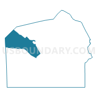
FRANKLIN TWP VTD 02, Adams County, Pennsylvania
About
Outline

Summary
| Unique Area Identifier | 655621 |
| Name | FRANKLIN TWP VTD 02 |
| County | Adams County |
| State | Pennsylvania |
| Area (square miles) | 44.41 |
| Land Area (square miles) | 44.07 |
| Water Area (square miles) | 0.34 |
| % of Land Area | 99.23 |
| % of Water Area | 0.77 |
| Latitude of the Internal Point | 39.92164300 |
| Longtitude of the Internal Point | -77.36016600 |
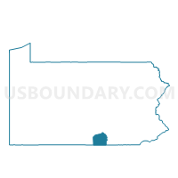
Maps

Graphs
Select a template below for downloading or customizing gragh for FRANKLIN TWP VTD 02, Adams County, Pennsylvania


Neighbors
Neighoring Voting District (by Name) Neighboring Voting District on the Map
- ARENDTSVILLE Voting District, Adams County, PA
- BUTLER TWP Voting District, Adams County, PA
- CUMBERLAND TWP VTD 01, Adams County, PA
- CUMBERLAND TWP VTD 03, Adams County, PA
- FRANKLIN TWP VTD 01, Adams County, PA
- GREENE TWP VTD 01, Franklin County, PA
- MENALLEN TWP Voting District, Adams County, PA
- SOUTHAMPTON TWP VTD UPPER PCT 02, Cumberland County, PA
Top 10 Neighboring County Subdivision (by Population) Neighboring County Subdivision on the Map
- Greene township, Franklin County, PA (16,700)
- Southampton township, Cumberland County, PA (6,359)
- Cumberland township, Adams County, PA (6,162)
- Franklin township, Adams County, PA (4,877)
- Menallen township, Adams County, PA (3,515)
- Butler township, Adams County, PA (2,567)
- Arendtsville borough, Adams County, PA (952)
Top 10 Neighboring Place (by Population) Neighboring Place on the Map
Top 10 Neighboring Unified School District (by Population) Neighboring Unified School District on the Map
- Chambersburg Area School District, PA (66,240)
- Shippensburg Area School District, PA (28,194)
- Gettysburg Area School District, PA (27,592)
- Upper Adams School District, PA (10,828)
Top 10 Neighboring State Legislative District Lower Chamber (by Population) Neighboring State Legislative District Lower Chamber on the Map
- State House District 89, PA (73,734)
- State House District 193, PA (67,435)
- State House District 91, PA (66,509)
Top 10 Neighboring State Legislative District Upper Chamber (by Population) Neighboring State Legislative District Upper Chamber on the Map
Top 10 Neighboring 111th Congressional District (by Population) Neighboring 111th Congressional District on the Map
Top 10 Neighboring Census Tract (by Population) Neighboring Census Tract on the Map
- Census Tract 131.01, Cumberland County, PA (9,116)
- Census Tract 105, Franklin County, PA (8,429)
- Census Tract 304, Adams County, PA (5,829)
- Census Tract 303, Adams County, PA (4,156)
- Census Tract 314.01, Adams County, PA (3,975)
- Census Tract 305, Adams County, PA (3,767)